


SAM 05-2973 Voting District, King County, Washington
About
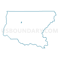
Outline

Summary
| Unique Area Identifier | 685033 |
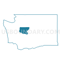
| Name | SAM 05-2973 Voting District |
| County | King County |
| State | Washington |
| Area (square miles) | 0.56 |
| Land Area (square miles) | 0.56 |
| Water Area (square miles) | 0.01 |
| % of Land Area | 98.91 |
| % of Water Area | 1.09 |
| Latitude of the Internal Point | 47.57210730 |
| Longtitude of the Internal Point | -122.03158420 |
Maps

Graphs
Select a template below for downloading or customizing gragh for SAM 05-2973 Voting District, King County, Washington


Neighbors
Neighoring Voting District (by Name) Neighboring Voting District on the Map
- Bowood Voting District, King County, WA
- ISS 05-2409 Voting District, King County, WA
- ISS 05-2602 Voting District, King County, WA
- ISS 05-3554 Voting District, King County, WA
- SAM 05-0909 Voting District, King County, WA
- SAM 05-1130 Voting District, King County, WA
- SAM 05-2937 Voting District, King County, WA
- SAM 05-3508 Voting District, King County, WA
- Waxwing Voting District, King County, WA
Top 10 Neighboring County Subdivision (by Population) Neighboring County Subdivision on the Map
Top 10 Neighboring Place (by Population) Neighboring Place on the Map
Top 10 Neighboring Unified School District (by Population) Neighboring Unified School District on the Map
Top 10 Neighboring State Legislative District Lower Chamber (by Population) Neighboring State Legislative District Lower Chamber on the Map
Top 10 Neighboring State Legislative District Upper Chamber (by Population) Neighboring State Legislative District Upper Chamber on the Map
Top 10 Neighboring 111th Congressional District (by Population) Neighboring 111th Congressional District on the Map
Top 10 Neighboring Census Tract (by Population) Neighboring Census Tract on the Map
- Census Tract 322.08, King County, WA (7,936)
- Census Tract 322.11, King County, WA (4,803)
- Census Tract 322.07, King County, WA (3,254)